
What is Waas? how does it improve gps for ifr flying?
- May 30, 2025
- 4 min read
Understanding GPS: A Clock and Radio in Space
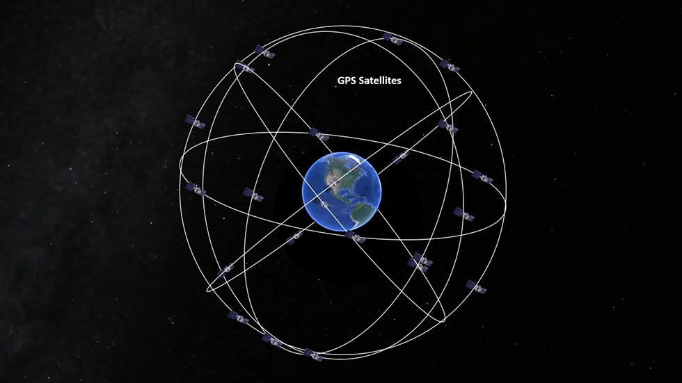
A GPS satellite can seem like an impossibly sophisticated feat of science, but it helps to think of it as simply a radio and a super precise clock, that we shot up into space. One satellite is part of a constellation of many more, that are in orbit around the Earth. They follow different orbital paths that are set up so that a certain number of these satellites should be visible from any point on Earth. These satellites are at an altitude about 11,000 miles above the planet, which means they are at a speed causing them to circle the globe in 12 hours. They are constantly in motion as observed from our relatively fixed position on the ground or in an aircraft. With a proper receiver on board, signals from these satellites give us a very accurate fix of our position.
Geostationary satellites and why they matter
More than three times higher than these satellites, in an orbit around the equator, sit some other hardware. These are geostationary satellites, their high orbit requires a slower speed (the same speed the Earth rotates at) which causes them to appear from the observer on Earth to remain motionless. They are always directly above some fixed point along the equator. Together, all of these satellites make up part of an even more precise navigation aid, called the Wide Area Augmentation System, WAAS for short.
GPS is a US military system and is designed for global usage. WAAS is an FAA program, and is designed for civilian aircraft operating in the National Airspace System, i.e. the United States. Again, the GPS satellites are constantly in motion relative to the ground, while the geostationary satellites hang over a fixed point on the equator, the southern sky as viewed from the Northern Hemisphere in the US.
The GPS satellites, being again very fancy clocks with radios, transmit a signal down towards the ground in all directions. An aircraft equipped with a GPS receiver picks up these signals. As long as a minimum number of satellites, for most purposes this is four, are being received. An aircraft’s on-board GPS unit can compute a position for it. But we kind of have to take the receiver’s word for it, we aren’t positive of our exact location, especially since we’re moving over the ground at a decent speed. These signals aren’t perfect, and are prone to errors due to position, radio interference, and a number of other factors.

Ground-based waas stations: Verifying gps accuracy
Can we check the accuracy of the system off a known position? We can do so, using a series of 38 ground stations spread out over North America. These are the wide area reference stations, “wide area” being the WA in the WAAS acronym. These stations are surveyed to an exact latitude and longitude position, and elevation above sea level.
The stations receive GPS signals and compute a position the same as our unit does on-board, though unlike us in our aircraft, they know their exact position, and can compare it to the GPS computed position, to determine errors. If the error is due to one satellite not functioning properly, the station will know to ignore it and use a position computed with another series of satellites. This information and other position errors will be transmitted by all stations, by terrestrial link, to master stations; there are three.
The master station is a computer system that collects all the error messages, and generates a user message. The user message is instructions for GPS receivers on how to handle the errors detected by the system. This message is beamed by uplink dishes to the geostationary satellites in the southern sky above the equator. This happens every second. By the way, this error correction principle is similar to what’s done with RAIM, Receiver Autonomous Integrity Monitoring, a term you may have heard, but is done continuously and much more accurately, and there are almost never planned outages, so it’s a wholly different concept we’ll leave for another lesson.

how waas improves gps accuracy for aircraft
For our aircraft, we receive the GPS signal as normal, but due to all the errors we talked about, there could be some variance between our reported position and where we actually are. If our GPS receiver is WAAS enabled, meaning it’s able to receive the user message generated by the WAAS system, we can take our GPS position, and augment (this is the second A in WAAS by the way) the data with the error info we get from the geostationary satellite. This takes a good deal of the error away. A non WAAS corrected GPS position can be expected to be accurate up to about 5 meters. With WAAS enabled, the accuracy gets down to less than one meter.
This may not seem like much in a sky that stretches on for miles in front of us, but it can make a huge difference in the types of instrument approaches we’re capable of flying. Most RNAV approaches require us to have an appropriate GPS receiver on board. A standard, non WAAS unit will be fine, but the degree of inaccuracy, especially in terms of altitude, can be restricted. With WAAS, the inaccuracy is much less, and we can actually follow a GPS derived glidepath, just like we would on an ILS, and fly this approach as we would a precision one. Allowing us to use lower minimums, the LPV numbers, and treat the minimum as a decision altitude, as opposed to using the higher LNAV minimums for units without WAAS, which are treated as a minimum descent altitude, the same way we would any non precision approach such as a VOR. Most newer GPS units are equipped with a WAAS receiver, make sure you know what you’re working with as you plan your IFR flights.

